
1996.009.00.0001 Mapa de San Juan Tolcayuca
Title
Mapa de San Juan TolcayucaCall number
1996.009.00.0001(Miami Lakes, FL, Jay I. Kislak Foundation)
Publisher
Jay I. Kislak FoundationLanguage
Nahuatl languagesOrigin
- Place
-
Tolcayuca (Mexico)
Summary
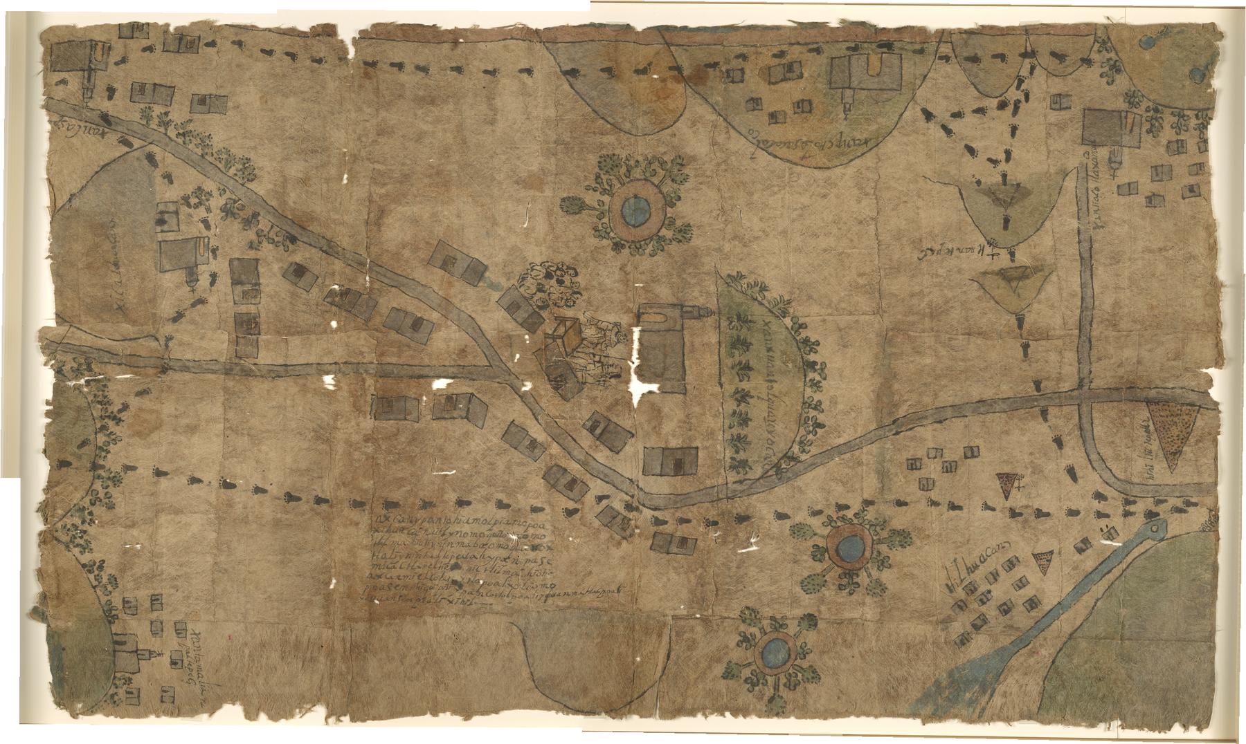
Illustrated Techialoyan manuscript map depicting the lands around the village of San Juan Tolcayuca on Amatl (Fig-tree bark) paper made to accompany a larger Techialoyan codex. Techialoyan codices are the generic name for a group of documents produced by the same team of scribes/artists in the Toluca Valley, Mexico. Around fifty examples of Techialoyan manuscripts are known to exist today. Each manuscript consists of two parts, a text written in the Nahuatl language and a pictorial section, with most drawings accompanied by brief Nahuatl descriptions. The group as a whole displays several common characteristics indicating that their authors followed a standard format for the organization of information and that they are most probably the product of a single workshop, completed by a small team of talented artists and scribes. Town jurisdictions, the community's acceptance of the Roman Catholic faith, the name of the local patron saint and the year in which the land grant was conferred on the village are delineated in the textual section of each manuscript. The manuscripts describe meetings of the notables of the town to confirm the territorial limits of the town, the places included, its districts, and its tributary towns. The object of this ceremony, a fusion of the ancient Mesoamerican and European cultural practices, was to legitimate possession of the land. The text and pictures complement each other and include the names of the notables present. The iconography is rich in representations of plants, architecture, and people, both indigenous and European. The residents of these towns would present these documents to a court to be translated, from Náhuatl to Spanish, and authenticated. At the end of the 17th century, the indigenous populations of Mexico had grown, and as a result were trying to recover lands that had been absorbed by haciendas, ranches, and other towns, and the viceregal government was searching for mechanisms to regularize land tenure. Indigenous documents were used as probate records to prove the antiquity of towns and their possession of lands. Towns sought to provide evidence that they were cabeceras (judicial seats), not subject populations, and old settlements with long-established borders. Among the motifs that appear with great frequency in these manuscripts are indigenous people, churches, hills, and plants. Texts also repeat in many of the documents, although in each case making reference to a particular town. The settlements that ordered a Techialoyan manuscript made sure that it contained essential information on the founding and history of the town. The dating of the Techialoyan manuscripts has proven problematic. In the text of each, dates are given ranging from 1505 to 1596, many attributing their land grants to the arrival in New Spain of Viceroy Antonio de Mendoza during late 1535. It is currently accepted that most date from ca. 1700 to 1743 and that they were created as a means for local people to defend their ancestral lands. Local communities were quick to recognize the value Spanish courts placed upon older documentation and thus, created antiqued the Techialoyan manuscripts as antique "forgeries" to support litigation cases and justification of ownership.
Extent
640 x 1070 mmFoliation
1 leafSupport
AmatlDecoration
Watercolor illustrations of human figures, buildings, churches, hills, and a river. Ink drawings of human footprints link many of the buildings in a circuit.
Subjects topical
- Indians of Mexico--Land tenure
- Tolcayuca (Mexico)
- San Juan Tolquauhyoca
Genres
- Maps
Keywords
- Charts
- Drawing
Licenses
-
- Text
- These images and the content of Jay I. Kislak Foundation, 1996.009.00.0001: Mapa de San Juan Tolcayuca are free of known copyright restrictions and in the public domain. See the Creative Commons Public Domain Mark page for usage details, http://creativecommons.org/publicdomain/mark/1.0/.
- URL
- http://creativecommons.org/publicdomain/mark/1.0/
-
- Text
- Metadata is ©2017 Jay I. Kislak Foundation and licensed under a Creative Commons Attribution License version 4.0 (CC-BY-4.0 https://creativecommons.org/licenses/by/4.0/legalcode. For a description of the terms of use see the Creative Commons Deed https://creativecommons.org/licenses/by/4.0/.
- URL
- https://creativecommons.org/licenses/by/4.0/legalcode
Images
 Map
Map5173_0000.tif (497.8 MB)
5173_0000_thumb.jpg (5.2 KB)
5173_0000_web.jpg (323.7 KB)
Decoration: Watercolor map of San Juan Tolcayuca